Fools Gold 38 Mile and 54 Mile Courses and Maps
Both courses begin at Montaluce Winery and will have a neutral rollout for approximately 3 miles on pavement, then transition to gravel roads. The 54 mile course begins with a stout 3 mile gravel road climb. The course will remain on the ridgeline gravel road for 6 miles all the way to Winding Stair Gap and Aid 1. A fast gravel descent then takes riders onto the singletrack of the Turner Creek Trail. From here, riders will descend back to FS 28-1, and join the 38 mile course for the remainder of the race, which includes the Jones Creek Dam Trail, Bull Mountain Trail and Loop, Jake Mountain Trail and Black Branch Trail.
The 38 mile course heads directly to the Jones Creek Dam Trail along gravel roads, giving riders the opportunity to space out. Essentially the shorter course just cuts off the first section of gravel road climbing and ridge riding, and heads directly to the singletrack loop.
Much of the singletrack is newly re-constructed and flowy, with an assortment of fast gradual climbs to short grunts. There is another 3 mile climb up Bull Mountain, and the descent on the Bull Mountain Trail is one of the best in the Southeast. This course has a good mix of all trail types and does not cater to any one particular style of rider, though fitness is rewarded due to the abundance of climbing. In terms of technical difficulty, the majority of the course is intermediate, with a few short, advanced sections throughout the course.
2025 Fool's Gold 38 Mile and 54 Mile Course Map
2025 Fools Gold 54 Mile Course Garmin Connect File
2025 Fools Gold 38 Mile Course Garmin Connect File
54 Mile GPX File
38 Mile GPX File
Bull and Jake Mountain Trail Map
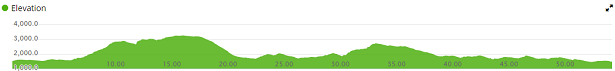
Below is the Elevation profile for the 54 mile course.
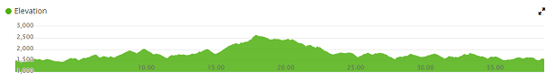
Below is the Elevation profile for the 38 mile course.

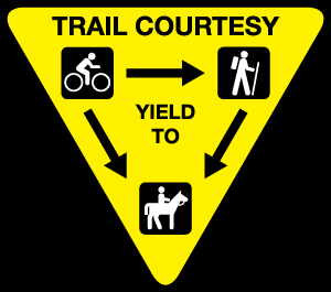
Please note if you are pre-riding, the Bull and Jake Mountain Trails are Multiuse, including Hikers and Horseback Riders. You MUST YIELD to Horses and Hikers. If you encounter a horse head-on, dismount your bike and move off the trail to allow the horse to pass. Horses are prey animals and can spook easily, causing the rider to be thrown and badly injured. Keep speed under control on blind corners that you cannot see around - there may be someone else out there other than you. Please exercise trail courtesy and help provide a safe environment for all users.
Rain Route
We are required to have an alternate course that does not include singletrack trail in the event of extremely wet weather or saturated soil conditions leading up to the race. This is for preservation of our wonderful trails as well as your equipment. The "Rain Route" will be similar to our Southern Cross Course with riders leaving Montaluce and taking Hightower Church Road to FS 28-1. Riders will turn right on FS 28-1 and continue climbing FS 80 to Cooper Gap. From Cooper Gap, riders turn left and continue on FS 42 to Winding Stair Gap. From there riders will turn right and descend FS 58 to Doublehead Gap Rd. At Doublehead Gap Road, riders will turn left and continue to FS 42 at the top of a large hill. At FS 42, riders turn left and continue on FS 42 past Springer Mountain and back up to Winding Stair Gap. Once up at the Gap, they will descend down FS 77, all the way to FS 28-1. At FS 28-1, riders make a left and continue to Hightower Church Road where they turn right to head back to Montaluce.
The decision to use the rain route will be made no later than Friday September 12, however, we most likely will announce it sooner if we are required to use it. Since 2014, we have had to use the rain route twice; in 2022 and 2024. Whether we use it is decided by the USFS, and we have to abide by their decision if we want to play bikes on their land, so we appreciate your understanding if we need to use the rain route.
IF THE RAIN ROUTE IS USED, YOU MUST STILL USE A MOUNTAIN BIKE - NO GRAVEL OR CYCLOCROSS BIKES.
2025 Fool's Gold Rain Route Map
If we experience heavy rain during the race, riders may be re-routed off of the singletrack and onto gravel roads to complete the course depending on the timing and severity of the rain. If this re-route occurs after some riders have already started the full course, all full course finishers will be ranked above short course finishers.